The national Point of Beginning was associated with the Rittenhouse and Elliot survey of 1785 marking the western boundary of PA and the south east corner of the Northwest Territory. Before 1785, the Ohio River had been the recognized boundary between the United States and Indian territory. Across the river from Georgetown, this survey point marked the starting point for the surveys of all public land west including Alaska, excluding the thirteen original colonies, Texas, and Hawaii. The phrase, the Point of Beginning, was clearly more significant than the name given the geographic survey marker. It referred to the spiritual and emotional heart of the American Dream – the springboard to the West.
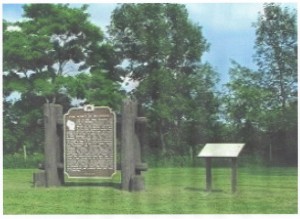
The Wisconsin public land surveys began in 1832 and were completed in 1867. Late in 1831, when Wisconsin was still in Michigan Territory, Lucius Lyon, U.S. Commissioner on the survey of the northern boundary of the State of Illinois, set a post to mark the intersection of that boundary and the 4th Principal Meridian. Every section corner monument in the state, the boundaries of each county, city, village, township, farm and lot; the position of roads, lakes and streams, all were surveyed and mapped from this Point of Beginning (POB).
As the historical marker explains, this is where Wisconsin begins, both geographically and historically. [i]
Of course, the POB for WI was mapped from the original POB marking the beginning of the Northwest Territory and the Commonwealth of PA which was across the Ohio River from Georgetown.
In the History of Wood County, Wisconsin, there are several interesting names in the Original Land Entries for Wood County, Wisconsin in 1856. No land was taken in this Township 25, Range 3 until 1856. [2] The first entries recorded included:
Township 25 Range 3 (Marshfield and Cameron) 1856
| Name Recorded | Sections | Steamer in 1856 |
| Jacob Poe | 1,2,3,and 11 | Belmont, Yorktown 1 |
| Adam Poe | 3 and 4 | Ella, Financier 2 |
| Thomas Poe | 11 and 12 | Georgetown |
| George W Ebert | 12 | Belmont, Washington City |
Before the Civil War, the Georgetown Poes had accumulated considerable wealth in the river transportation business. With their boats, they were delivering settlers and supplies to the lower Missouri River towns. All the river ports on the Missouri River became wealthy outfitting emigrants following the Mormon, the Oregon, and the Santa Fe Trails. In the years leading to 1856, the boats operated by Georgetown men are also listed in the table. All of the named steamers were succesful. Only the str Georgetown was fataly snagged on the lower Missouri.
Profits from their steamboats were apparently invested in land. In 1856, Jacob Poe, Adam Poe, Thomas Poe and George W Ebert acquired or “marked” land in Wood County, WI. Whether their names are woven in the history of the county is unclear. Remembered or forgotten, they laid the foundation for the history of the county.
What became of their investments is unknown. Why they would chose to acquire land in themiddle of an unsettled frontier territory without access to a major river is also open to speculation. Sections 11 and 12 are adjacent to Sections 1 and 2 indicating that these four steamboat captains “marked” 6 square miles of land to settle together. (According to the system of metes and bounds one Range was 6 miles; one Section was approximately 1 square mile; one township was comprised of 36 sections.) Whether I stand to benefit from my ancestor’s investment is still to be settled.
References.
[i] http://www.howderfamily.com/blog/the-point-of-beginning-wisconsin/
[2] George O Jones, History of Wood County, Wisconson, HC Cooper Jr and Cooper, 1923, p70.
Copyright © 2015 Francis W Nash
All Rights Reserved
No part of this website may be reproduced without permission in writing from the author.
