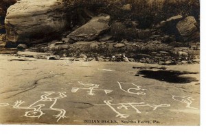
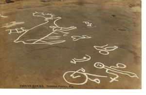
The Indian Rocks
The Indian Rocks, located in Smiths Ferry across the river from Georgetown, were landmarks until dredging operations for the Stratton Dam at New Cumberland, WV. That canalization progress resulted in deeply burying the rocks, presumably never to be uncovered. Opened for traffic in Nov 1959, the Stratton Dam also increased the water level of the river by approximately ten feet at Georgetown. If the petroglyphs were not buried by dredging, the water level will probably never again be low enough to see the images.
Before the Stratton Dam was erected, the Ohio River was known to dry up at Smiths Ferry during the summer season and people traveled by horse and buggy from as far as Pittsburgh, crossing over the dry river bed, to view the historical Indian site. Pictures of Smiths Ferry’s Indian Rocks have been printed in the National Geographic and in Bausman’s History of Beaver County.
These images are real photo postcards (RPPCs) dated 1908. To photograph the petroglyphs, white chalk was placed into the carved depressions and the photos were often taken from ladders.
More photos are loaded on the page Indian Rocks.
Copyright © Francis W Nash
All Rights Reserved

