The Point of Beginning
A little known but importance part of early American history was the Point of Beginning. The Point of Beginning was associated with the Rittenhouse and Elliot survey of 1785 marking the western boundary of PA and the south east corner of the Northwest Territory. Before 1785, the Ohio River had been the recognized boundary between the United States and the Northwest Territory which was Indian territory.
Across the river from Georgetown, the survey point of 1785 marked the starting point for the survey of all public land west including Alaska, excluding only the thirteen original colonies, Texas, and Hawaii. The phrase, the Point of Beginning, was clearly more significant than the name given one geographic survey marker. It referred to the spiritual and emotional heart of the American Dream – the springboard to the West. In the story of the expansion of our country, the Point of Beginning was the opening paragraph, and Georgetown was at the center of it all. The Historical Marker Data Base has an entry, HMdb Pt of Beginning, mapping the marker showing its proximity to Georgetown.
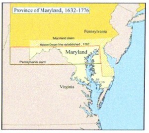
In order to settle eighteenth century armed border disputes or more precisely wars between PA and MD, PA and VA, and MD and DE, a survey was ordered by the British Crown. The surveyors were Charles Mason and Jeremiah Dixon and their work has historically become known as the Mason-Dixon Line symbolizing the cultural boundary between the North and the South. The survey was conducted between 1763 and 1767. Both Mason and Dixon returned to England when their westward progress was stopped by the threat of Indian attack.
Yet the truth be told, disputes continued. The western boundary of PA was not established by the Mason-Dixon Line. VA and PA continued to contest the land south of the Ohio River and west of the Youghiogheny River. The nebulous western boundary line was an outline of constant friction between the French, English, Indian, Virginian, and Pennsylvanian. As part of the Land Ordinance Act of 1785, the government financed a survey of the western boundary of PA. That survey was completed on Aug 23, 1785. Like the Mason Dixon Line survey team, there were two lead surveyors: David Rittenhouse from PA and Andrew Ellicott from VA, but the boundary has become known historically as the Ellicott Line. Chaired by Thomas Jefferson, The Land Ordinance Act of 1785 has been called the greatest subdivision of land on Earth. The spot is also registered among our National Historic Landmarks.
Timbermen and stonemasons traveled with the surveyors, Rittenhouse and Elliot. A path twenty feet wide was cleared and stones carved with a “P” on the east and a “V” on the west were set on every hilltop along the western border. The last VA and PA marker was placed on the river bank just down river from Georgetown where the western border line of PA entered the Ohio River. Next to that marker is another cut stone survey marker that was installed in 1881 with a “P” and a “WV”. Both markers are on private property owned by FirstEnergy Corp. Permission must be obtained to visit these national treasures.
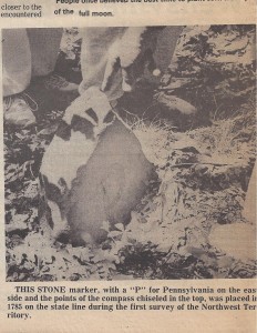
Pt of Beginning Marker from The Evening Review Weekend Friday, May 15, 1987, p4 (Anna L and John F Nash Collection)
The original Point of Beginning marker was set near the Ohio River opposite Georgetown. It has been lost, probably to the rise in the river level due to the canalization of the Ohio. This image of the marker was printed in The Evening Review Weekender on 15 May 1987. The image has no attribution to identify the photographer or the date of the photo.
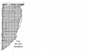
The Land Ordinance of 1785 also ordered that public land surveys were required before any land could be sold in the Northwest Territory. Thomas Hutchins was appointed the Geographer of the US and was to be assisted by thirteen surveyors, one per state. The instructions from Congress required the Geographer to run a line west from the Point of Beginning. At six mile intervals, called ranges and marked with a stone monument, another line was required to run due south to the Ohio River. The line west became known as the Geographer’s Line. Hutchins and his team of surveyors began their work on 30 Sep 1785. After four miles the Public Land Surveys were suspended, like Mason and Dixon, because Hutchins received word that he would be attacked by Indians.
Georgetown , one of the earliest settlements west of Fort Pitt, was at the center of much frontier activity including the Point of Beginning. In 1785, Thomas Hutchins and his crew stayed in a home in Georgetown while they conducted the survey of the Northwest Territory. In Sep 1799 long time Georgetown resident and pioneer surveyor, John Bever, surveyed Range Number 3. His maps according to Ohio historian Thomas J Malone were “extremely interesting for their detail and the field notes that accompany them”. [2] The land sold slowly due to the presence of illegal settlers and continued threat of Indian attacks.
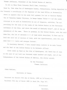
On 10 Jun 1808 Adam Poe, the Indian fighter, purchased Lot or Section Number Ten of Township Number Thirteen in Range Number Three. He lived his remaining days in Ohio.
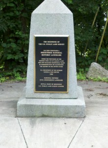
The historical monument marking the Point of Beginning was erected in a roadside park by the PA DOT exactly 1,112 feet from the original stake near the river shore.[1] Additional photos of my visit to the Point of Beginning have been loaded on the page Point of Beginning Photos.
References.
[1] Denver and Eugenia Walton and Bob Bauder, Rivers of Destiny, Beaver county Historical and Landmarks Foundation, 1999, pg 67-68.
Copyright © 2011 Francis W Nash
All Rights Reserved
